This price includes DELIVERY, and VAT if applicable.
read more
Locale of work: England, Sussex
Category:
Maps
Print Category:
Antique Maps
Subject Category:
Historical And Maps And Midhurst - Local & Surrounding Area
Colour: Colour
Colour Application: With Original Hand Colour
Verso: There is nothing printed on the reverse side, which is plain.
Condition of Artwork: Very good for its age. Some very small minor marks, two small spots of foxing. The edges of the paper are somewhat torn and tattered, but even cropping would still leave ample margins for mounting and framing.
Cartographer:
CREIGHTON,
R.
Engraver:
WALKER,
J. & C.
Publisher: Published by Samuel Lewis and Co., London: 3rd Edition.
Publication Magazine: A Topographical Dictionary Of England, 3rd Edition. (1835)
Edition Series Volume: Plate XC.
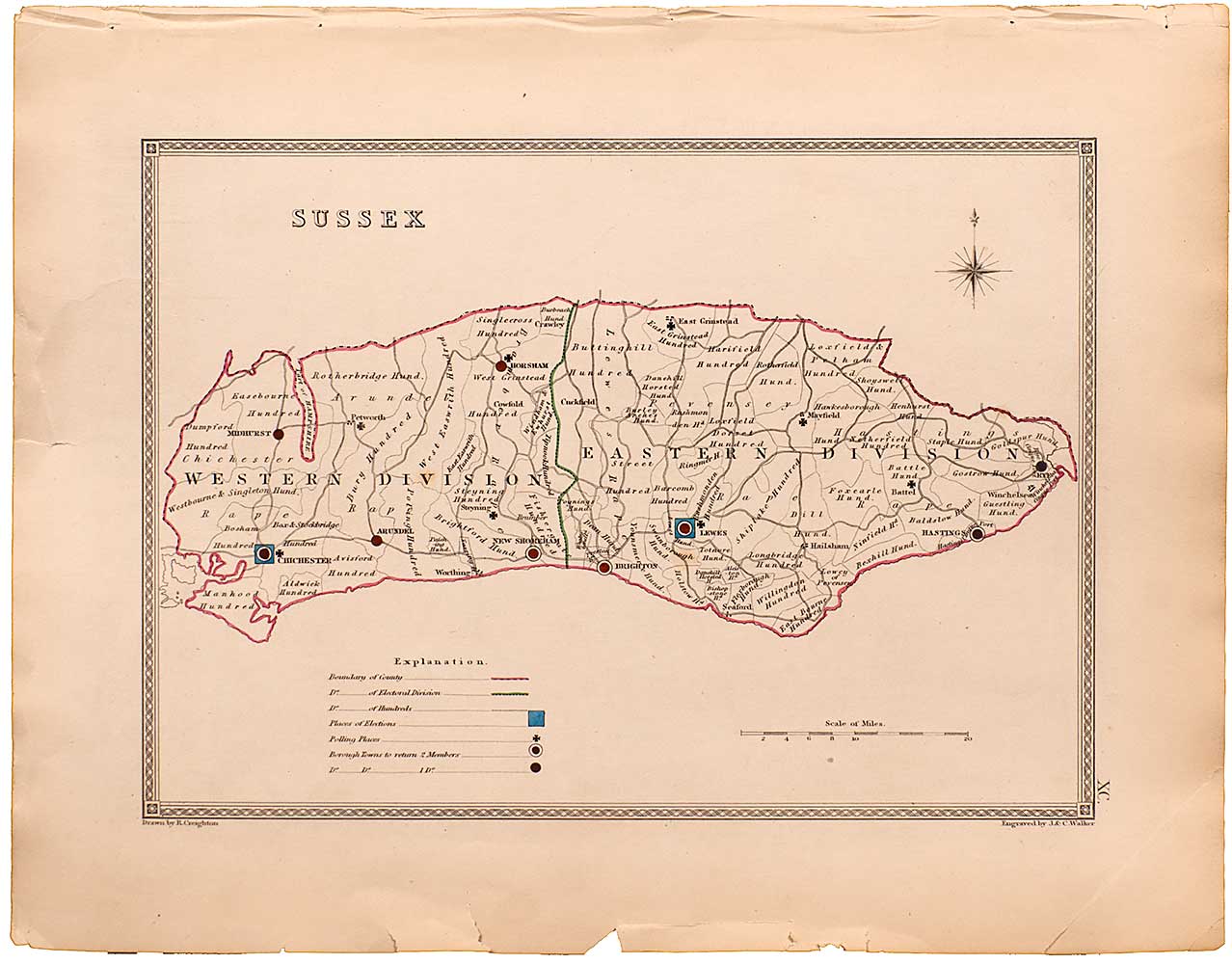
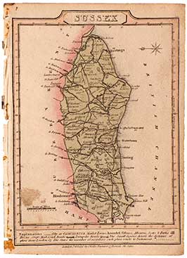
Notes: An original antique steel engraved map showing the Eastern and Western Divisions in Sussex. This map was engraved by J. & C. Walker after plans produced by R. Creighton. These plans were originally drawn up to depict the 'former and present' boundaries of cities and boroughs, in relation to the great Reform Act of 1832. This map is in fine and clean condition and shows the electoral divisions, places of election, polling places and the Borough Towns entitled to return Members of Parliament. bearing original hand colour and with an explanation at the bottom. Published in Samuel Lewis's "A Topographical Dictionary of England", 3rd Edition (1835).
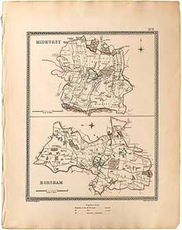
Sussex: Midhurst & Horsham Town Plans (2)
An original antique steel engraved map showing the towns of "Midhurst" (top) and "Horsham" (bottom) in Sussex. This map was engraved by J. & C.....
Arundel, Hastings & Rye Town Plans
Original antique steel engraved maps; showing the towns of "Winchester" (top left); "Southampton" (top right) in Hampshire, and "Petersfield" (bottom) in West Sussex. These maps....
New Shoreham Town Plans
An original antique steel engraved map showing the town of "New Shoreham", in West Sussex. These maps were engraved by J. & C. Walker after....
Petersfield, Winchester & Southampton Town Plans
An original antique steel engraving showing the towns of "Winchester" (top left); "Southampton" (top right) in Hampshire, and "Petersfield" (bottom) in West Sussex. These maps....
Sussex Divisions Map
An original antique steel engraved map showing the Eastern and Western Divisions in Sussex. This map was engraved by J. & C. Walker after plans....
Sussex: Midhurst & Horsham Town Plans (1)
An original antique steel engraved map showing the towns of "Midhurst" (top) and "Horsham" (bottom) in Sussex. This map was engraved by J. & C.....
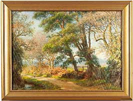
Autumn Walk
URN: 3.03
An Original Oil Painting on board by Francis Hurst Eastwood.
The date that the British born artist created this painting is unknown.
The image measures....
Sunshine Cottage
URN: 3.05
An Original Oil Painting on board by Francis Hurst Eastwood.
Created circa 1915 by the British born artist.
The image measures 54 x 37....
Map Of Sussex
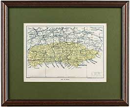
An original 'vintage' lithograph print showing a detailed map of Sussex. Printed in around 1923 by Geographica Ltd, 55 Fleet Street, London EC4. As this....
Map: Sussex
An original copper engraving from 1821. This is an attractive antique map of Sussex, drawn and engraved by John Cary over 190 years ago. This....
Sussex Map from The New British Traveller (1)
A lovely original copper engraved map of Sussex, by cartographer Samuel John Neele in 1818. With original hand colour, a hatched title pane, compass, scale....
Miniature Sussex Map
A charming, miniature county map of Sussex, in its full original colour. This is an original, antique, copper engraved county map published in 1812. This....
"Roads To..." London To Bognor (Including Eastbourne, Brighton Etc.) (1)
This antique copper engraving is Plate 2 from the first edition of "Laurie and Whittle's New Traveller's Companion", published 12th February, 1806. This artwork's full....
Dugdale's Map Of Sussex
An attractive and detailed map of Sussex, drawn and engraved by J. Archer, Pentonville, London. This is an early steel engraving which dates from around....
"Roads To..." London To Bognor (Including Eastbourne, Brighton Etc.) (2)
This antique copper engraving is Plate 2 from a later edition of "Laurie and Whittle's New Traveller's Companion", published in 1818.
Its full title is....
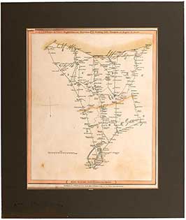
Sussex Divisions Map
An original antique steel engraved map showing the Eastern and Western Divisions in Sussex. This map was engraved by J. & C. Walker after plans....
Knitting Socks For Soldiers
URN: 3.31.
An Original Oil Painting on board by Francis Hurst Eastwood.
The date that the British born artist created this painting is unknown.
The image measures....
Nelson's Ship The Victory In The Battle Of Trafalgar
This is a later Restrike Etching after the original painting in 1824 by J. M. W Turner (RA) of Nelson's ship, The Victory, at the....
Caserne Suisse, Rue De Babylon, 29 Juillet, 1830.
An antique steel engraving, published in "Paris & its Environs" ( 1928 - 1931).
Entitled: 'Caserne Suisse, Rue de Babylon, 29 Juillet, 1830.' Drawn by J.....
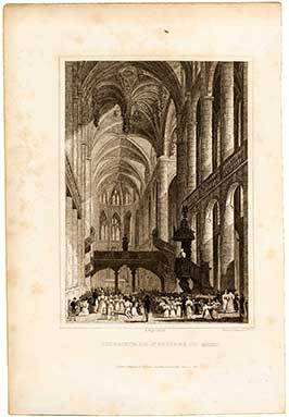
Interieur De St. Etienne Du Mont
An antique steel engraving, published in "Paris & its Environs" ( 1928 - 1931).
Entitled: 'Interieur de St. Etienne du Mont.' Engraved by Fenner, Sears &....
Depart de la Populace, pour Rambouillet
An antique steel engraving, published in "Paris & its Environs" ( 1928 - 1931).
Entitled: 'Depart de la Populace, pour Rambouillet.' Drawn by J. Nash, and....
Incendie de la Barriere St. Denis, 29 Juillet, 1830
An antique steel engraving, published in "Paris & its Environs" ( 1928 - 1931).
Entitled: 'Incendie de la Barriere St. Denis, 29 Juillet, 1830.' Drawn by....
Niddre Castle - Chateau De Niddrie.
An original 1844 steel engraving by G. Presbury after a drawing by H. Melville. This artwork depicts a scene from Scott's novel 'The Abbot' (1837)....
Sussex: Midhurst & Horsham Town Plans (2)
An original antique steel engraved map showing the towns of "Midhurst" (top) and "Horsham" (bottom) in Sussex. This map was engraved by J. & C.....
Strip Road Map: London To Arundel
An original copper engraved map, showing the road from 'London to Arundel' with Fittleworth, Petworth and Little Hampton along the way. This is an antique....
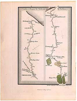
Strip Road Map: London To Bognor...
An original antique copper engraved map, showing the road from 'London to Bognor by Chichester and by Eartham'. These are plates 41 & 42 by....
Strip Road Map: London To Portsmouth (Pl. 27 & 28)
An original copper engraved map, showing the road from 'London to Portsmouth' with Mousall, Milford, Godalming, Guildford, Hindhead Heath, Devil's Punch Bowl and Hammer along....
Arundel, Hastings & Rye Town Plans
Original antique steel engraved maps; showing the towns of "Winchester" (top left); "Southampton" (top right) in Hampshire, and "Petersfield" (bottom) in West Sussex. These maps....
New Shoreham Town Plans
An original antique steel engraved map showing the town of "New Shoreham", in West Sussex. These maps were engraved by J. & C. Walker after....
Petersfield, Winchester & Southampton Town Plans
An original antique steel engraving showing the towns of "Winchester" (top left); "Southampton" (top right) in Hampshire, and "Petersfield" (bottom) in West Sussex. These maps....
Miniature Sussex Map
A charming, miniature county map of Sussex, in its full original colour. This is an original, antique, copper engraved county map published in 1812. This....
Tunbridge Wells Miniature Map
An original, miniature, copper engraved map showing the town of Tunbridge Wells in western Kent. Printed for Richard Phillips, London, and published in "Guide to....
Worthing, Little Hampton & Great Bognor Miniature Map
A very nice original, antique, miniature copper engraved map; showing the towns of Worthing, Littlehampton and 'Great' Bognor in West Sussex. Printed for Richard Phillips,....
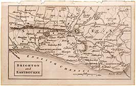
Brighton & Eastbourne Miniature Map
A very nice original, miniature, copper engraved map; showing the towns of Brighton and Eastbourne in East Sussex. Printed for Richard Phillips, London, and published....
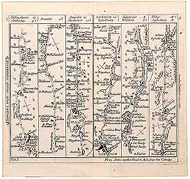
Bowle's Strip Map: Arundel To Chichester & London To Aylesbury
An original antique Strip Map showing Plate 8, The Road from London to Aylesbury (right), including Edgeware, Watford and Tring along the way. On the....
"Roads To..." London To Bognor (Including Eastbourne, Brighton Etc.) (1)
This antique copper engraving is Plate 2 from the first edition of "Laurie and Whittle's New Traveller's Companion", published 12th February, 1806. This artwork's full....
Midhurst Map From The Ordnance Survey (1)
An original antique lithographic map of Midhurst and environs, from the Ordnance Survey, by Lt. R. K. Dawson. This map dates from around 1832; it....
Switzerland Map
An original steel engraved map of Switzerland, drawn and engraved by J. Rapkin in 1851. This is a particularly fine and detailed map; decorated with....
Christchurch Map From The Ordnance Survey (1)
An original antique lithographic map of Christchurch and its environs, from the Ordnance Survey, by Lt. R. K. Dawson with lithography by J. Netherclift. This....
Thomas Moule's 1830 Map Of Hampshire (1)
A modern offset lithography print of Thomas Moule's original plates published over 180 years ago. Moule's plates were originally published in "The County Maps of....
Dugdale's Map Of Sussex
An attractive and detailed map of Sussex, drawn and engraved by J. Archer, Pentonville, London. This is an early steel engraving which dates from around....
"Roads To..." London To Bognor (Including Eastbourne, Brighton Etc.) (2)
This antique copper engraving is Plate 2 from a later edition of "Laurie and Whittle's New Traveller's Companion", published in 1818.
Its full title is....
Sussex Divisions Map
An original antique steel engraved map showing the Eastern and Western Divisions in Sussex. This map was engraved by J. & C. Walker after plans....
Sussex: Midhurst & Horsham Town Plans (1)
An original antique steel engraved map showing the towns of "Midhurst" (top) and "Horsham" (bottom) in Sussex. This map was engraved by J. & C.....
A Plan Of The Harbour Of Brest / A Plan Of The Bay & Roads Of Cadiz
An original antique copper engraved map, drawn and engraved by John Cary, this artwork is around 235 years old. The top map is entitled "A....
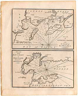
Plan Of Rochfort & Rochel / Plan Of The Bay & Roads Of Toulon
An original antique copper engraved map, drawn and engraved by John Cary. The top map is entitled "Plan of Rochefort & Rochel, with the Islands....
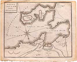
The Road Of Toulon With The Adjacent Country
An original antique copper engraved map, drawn and engraved by John Cary around 235 years ago. Entitled "The Road of Toulon with the Adjacent Country".....
Midhurst Map From The Ordnance Survey (3)
An original, antique, lithograph map of Midhurst and environs, from the Ordnance Survey, by Lt. R. K. Dawson. This map dates from around 1832, making....
Parish Church, Midhurst.
A rare antique steel engraving of Midhurst Parish Church as it stood in the late 19th century.
This artwork's artist is unattributed, but it was engraved....
Cowdray Park Chromolithograph (2)
An original antique 1870 chromolithograph of Cowdray Park Ruins in Midhurst, West Sussex.
This image was drawn by Alexander Lydon (1836 - 1917) and printed....
North Street, Chichester 107/850
A very attractive limited edition print, by the British born artist Philip Martin. This print shows a view of North Street in Chichester, near Midhurst....
Knockhundred Row, Midhurst (1)
An antique lithograph print of a watercolour painting by Wilfrid Ball (R. E.). This print shows Knockhundred Row in Midhurst, West Sussex painted by the....
Mill Pond, Midhurst (1)
An antique lithograph print of a watercolour painting by Wilfrid Ball (R. E.). This print shows 'Mill Pond' in Midhurst, West Sussex (which is now....
Mill Pond, Midhurst (2)
An antique lithograph print of a watercolour painting by Wilfrid Ball (R. E.). This print shows 'Mill Pond' in Midhurst, West Sussex (which is now....
The Public Library, Midhurst (B&W)
This is a modern digital print from an original drawing by Roger N. Calton showing The Public Library on Knockhundred Row in Midhurst, West Sussex.....
Midhurst Ruins (B&W)
This is a modern digital print from an original drawing by Roger N. Calton showing Cowdray Ruins with the River Rother flowing in the foreground,....
The Public Library, Midhurst (1)
This is a modern digital print from an original watercolour by Roger N. Calton showing The Public Library on Knockhundred Row in Midhurst, West Sussex.....
Midhurst Ruins (1)
This is a modern digital print from an original watercolour by Roger N. Calton showing Cowdray Ruins with the River Rother flowing in the foreground,....
King Edward VII Hospital, Midhurst
This is a modern digital print from an original watercolour by Roger N. Calton showing the now closed Kind Edward VII Hospital in Midhurst, West....
Ploughing On The Sussex Downs (1).
A full page antique wood engraving from a 1881 edition of The Illustrated London News. Engraved by W. M. R. Quick after a drawing by....
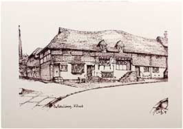
Cobden's Birthplace, at Midhurst (1).
A small attractive wood engraving, from an unconfirmed publication. Although we cannot attribute a date to this artwork, we can guarantee that it is over....
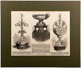
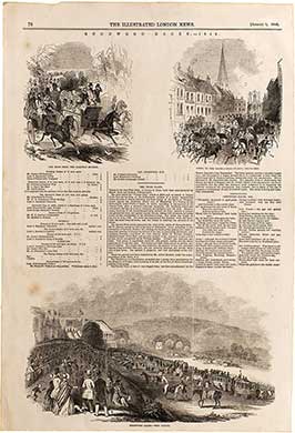
Goodwood Races 1862 - The Goodwood Cup, The Stewards' Cup, The Chesterfield Cup.
An antique wood engraving making up a partial page from an 1862 edition of The Illustrated London News. This selection of engravings shows 'The Goodwood....
The Ladies' Lawn At Goodwood
An antique copper engraving making up a partial page of the August 6th, 1864 edition of The Illustrated London News. This engraving shows the crowds....
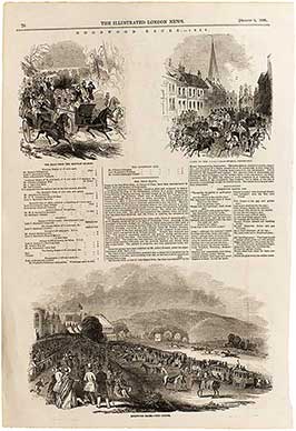
Goodwood Races: "Here They Come!" (1)
An full page antique wood engraving from the July 31st, 1875 edition of The Illustrated London News. This engraving shows the rowdy and raucous crowds....
A Sketch From The Lawn At Goodwood (1)
A full page wood engraved artwork from The Illustrated Sporting and Dramatic News, 1878. This antique engraving shows the wealthy and well dressed crowds gathering....
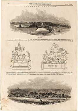
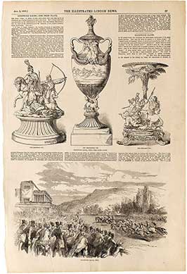
"Starke", The Winner Of The Goodwood Cup
An original full page from the August 10th, 1861 edition of The Illustrated London News. This page shows two detailed wood engravings; at the top....
"The Duke", Winner Of The Goodwood And Brighton Cups (1)
An original full page from the August 11th, 1866 edition of The Illustrated London News. This page shows two detailed wood engravings; at the top....
"New Holland", Winner Of The Goodwood Cup.
An original full page from the August 5th, 1876 edition of The Illustrated London News. This page shows two detailed artworks; the first at the....
Goodwood Race Prize Plate / Going To The Races (1)
An original full page from the July 30th, 1859 edition of The Illustrated London News Supplement. This page shows two detailed wood engravings; the first....
Goodwood House - Scene In The Park. / Road Through Goodwood Park. / Mr George Payne - Steward. (1)
An original full page from the August 3rd, 1844 edition of The Illustrated London News; showing three detailed wood engravings. The first at the top....
Goodwood Races - Weighing In. / Prize Plates Incl. "The Cup." / Gypsies In The Park / The Road...(1)
An original full page from the August 3rd, 1844 edition of The Illustrated London News; showing four detailed wood engravings. The first at the top....
Goodwood Races (1)- The Course /The Goodwood Cup. The Stewards' Cup /Entrance To The Park, Goodwood
An original full page from the August 2nd, 1845 edition of The Illustrated London News; showing three plates of detailed wood engravings. The first at....
Goodwood Races (1) The Road From The Railway Station /Going To The Races -High Street, Chichester...
An original full page from the August 1st, 1846 edition of The Illustrated London News; showing three plates of detailed wood engravings depicting the journey....
Goodwood Races, 1850 / The Prize Plate (1)
An original full page from the August 3rd, 1850 edition of The Illustrated London News; showing two plates of detailed wood engravings. The first, across....
Goodwood Races - The Road From The Railway Station. / Going To The Races - High Street, Chichester.
An original full page from the August 1st, 1846 edition of The Illustrated London News; showing three plates of detailed wood engravings depicting the journey....
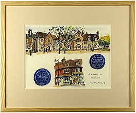
Old Midhurst
An original artwork in pen & ink on paper, by the artist Martin Millard. This is a lovely original work entitled 'Old Midhurst', compiling four....
H. G. Wells In Midhurst
An original artwork in pen & ink on paper, by the artist Martin Millard. This is a lovely original work entitled 'H.G. Wells in Midhurst',....
Midhurst Scenes
An original artwork in pen & ink on paper, by the artist Martin Millard. This is a lovely original work entitled 'Midhurst Scenes', compiling six....
The Victory, Portsmouth 749/850
A very attractive limited edition print, by the British born artist Glyn Martin. This print shows Nelson's iconic and historic flagship, 'The Victory'; the world's....
Contact us About this Artwork
I have an enquiry about:
This artwork is for Collection Only from The Midhurst Gallery either by you or by someone whom you authorise. Please refer to Para 7.12 of our T&Cs for details about Collections.
This Collection item requires to be in its own basket. If you have other items in your basket you will find them in your 'Saved for Later'.