Cartographer : DAWSON, Lt. Robert Kearsley((R.E.))
Artwork Name:
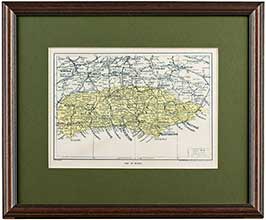
Chichester, From The Ordnance Survey
- c.1831
Printing Process:
Lithograph
Support Surface:
Paper
Overall Size (w x h, cms): 31 x 44 cms
Image Size (w x h, cms): 18 x 30.5 cms
Price: £95.00
This price includes DELIVERY, and VAT if applicable.
read more
Locale of work: England, Chichester, West Sussex
Category:
Maps
Print Category:
Antique Maps
Subject Category:
Maps And Midhurst - Local & Surrounding Area
Colour: Colour
Colour Application: Original Hand Colour
Verso: Affixed to backboard: 2x Double-sided pages of text entitled 'Chichester. Report upon the Proposed Municipal Boundary and Division into Wards of the City of Chichester. In Municipal Corporation Boundaries (England and Wales)'.
Condition of Artwork: Some minor, light foxing spots.
Framing State: Framed, Mounted, Glazed
Cartographer:
DAWSON,
Lt.
Robert Kearsley
(R.E.)
Lithographer:
NETHERCLIFT,
J.
Publication Magazine: The Ordnance Survey (1831)
Edition Series Volume: From the Ordinance Survey, c.1831.
Notes: An original, antique lithograph of Chichester in 1831. This map was drawn up by the well known cartographer Lieutenant Robert Kearsley Dawson (R.E.).
Robert K. Dawson, who was commisioned to the Royal Engineers and between 1819 and 1829 took part in the triangulation and mapping of Ireland and Scotland under Thomas Colby, was recalled to England to survey the boundaries of the proposed Parliamentary Boroughs for the Great Reform Act; producing a series of one-inch and two-inch maps.
This is one of those maps produced; printed in 1831 by J. Netherclift for the Ordanance Survey, it shows Chichester as it was some 185 years ago.
This piece has been nicely mounted, framed and glazed; with hanging attachments on the back.
Affixed to backboard are 2 double-sided pages of text entitled 'Chichester. Report upon the Proposed Municipal Boundary and Division into Wards of the City of Chichester. In Municipal Corporation Boundaries (England and Wales)'.
Chichester, From The Ordnance Survey
An original, antique lithograph of Chichester in 1831. This map was drawn up by the well known cartographer Lieutenant Robert Kearsley Dawson (R.E.).
Robert K.....
Midhurst Map From The Ordnance Survey (1)
An original antique lithographic map of Midhurst and environs, from the Ordnance Survey, by Lt. R. K. Dawson. This map dates from around 1832; it....
Christchurch Map From The Ordnance Survey (1)
An original antique lithographic map of Christchurch and its environs, from the Ordnance Survey, by Lt. R. K. Dawson with lithography by J. Netherclift. This....
Midhurst Map From The Ordnance Survey (3)
An original, antique, lithograph map of Midhurst and environs, from the Ordnance Survey, by Lt. R. K. Dawson. This map dates from around 1832, making....
Chichester, From The Ordnance Survey
An original, antique lithograph of Chichester in 1831. This map was drawn up by the well known cartographer Lieutenant Robert Kearsley Dawson (R.E.).
Robert K.....
Chichester Market Cross
A Lithograph Print from an original Pencil and Watercolour by Adrian Hill in circa 1945.
The original watercolour was from 'Recording Britain'; a collection of topographical....
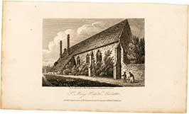
St Mary's Hospital, Chichester.
Published 1, March 1810 for the 'Antiquarian & Topographical Cabinet' by J. Storer (1810).
An original copper engraving drawn and engraved by J. Storer for the....
St Mary's Hospital Chichester, Sussex
An antique steel engraving drawn by T. Higham in around 1821 and engraved by J. Greig. This artwork is uncoloured and shows 'St Mary's Hospital....
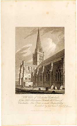
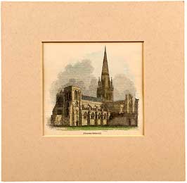
N. W. View Of Chichester Cathedral.
Drawn and engraved by J. Storer; this is Plate 2. from "The History and Antiquities of the Cathedral Church of Chichester" published 1, May, 1814.....
St Mary's Hospital Chichester
An original copper engraving drawn and engraved by J. Storer for the 'Antiquarian & Topographical Cabinet', published March 1, 1810. This uncoloured antique artwork shows....
Southeast View Of Chichester Cathedral
An original copper engraving drawn and engraved by J. Storer for the 'Antiquarian & Topographical Cabinet', published 1, October 1809. This uncoloured antique artwork shows....
S. Trancept Chichester Cathedral
An original copper plate engraving by J. Storer from a drawing by his brother, H. S. Storer. A fine piece showing the South Trancept....
N. West Entrance, Chichester Cathedral
An original copper engraving drawn by J. Storer and engraved by J. Greig for the 'Antiquarian & Topographical Cabinet', published 1, October 1809. This uncoloured....
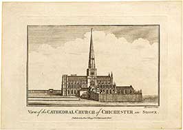
View Of The Cathedral Church Of Chichester In Sussex.
This is an original copper engraving by Thornton, showing a View Of The Cathedral Church Of Chichester In Sussex as it stood in the latter....
St Mary's Hospital Chichester, Sussex.
An antique copper engraving drawn by T. Higham in around 1820 and engraved by J. Greig. This artwork is uncoloured and shows 'St Mary's Hospital....
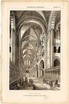
The Choir. As Restored (before The Erection Of The Reredos)
An antique copper engraving (Plate VI.) by F. Stockdale in around 1870. This artwork is uncoloured and shows the 'The Choir. As restored (before the....
Interior Of Chichester Cathedral
A copper engraving (Plate 8.) from 1814, drawn and engraved by J. Storer. This artwork is uncoloured and shows the 'Interior of Chichester Cathedral', in....
North Street, Chichester 107/850
A very attractive limited edition print, by the British born artist Philip Martin. This print shows a view of North Street in Chichester, near Midhurst....
Chichester Cathedral
Chichester Cathedral in c.1844 - Antique woodcut/ wood engraving by Jackson. Mounted.
Chichester Cathedral Lithograph
Chichester Cathedral in c.1908 - Antique colour lithograph by William Wiehe Collins (RI).
Chichester, From The Ordnance Survey
An original, antique lithograph of Chichester in 1831. This map was drawn up by the well known cartographer Lieutenant Robert Kearsley Dawson (R.E.).
Robert K.....
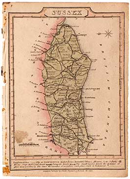
Map: Sussex
An original copper engraving from 1821. This is an attractive antique map of Sussex, drawn and engraved by John Cary over 190 years ago. This....
Sussex Map from The New British Traveller (1)
A lovely original copper engraved map of Sussex, by cartographer Samuel John Neele in 1818. With original hand colour, a hatched title pane, compass, scale....
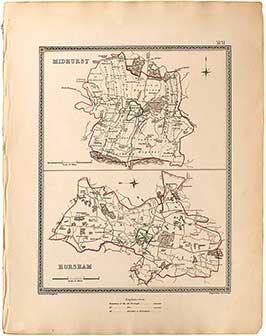
Sussex: Midhurst & Horsham Town Plans (2)
An original antique steel engraved map showing the towns of "Midhurst" (top) and "Horsham" (bottom) in Sussex. This map was engraved by J. & C.....
Strip Road Map: London To Arundel
An original copper engraved map, showing the road from 'London to Arundel' with Fittleworth, Petworth and Little Hampton along the way. This is an antique....
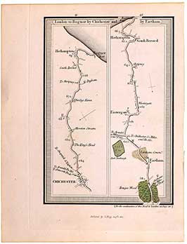
Strip Road Map: London To Bognor...
An original antique copper engraved map, showing the road from 'London to Bognor by Chichester and by Eartham'. These are plates 41 & 42 by....
Strip Road Map: London To Portsmouth (Pl. 27 & 28)
An original copper engraved map, showing the road from 'London to Portsmouth' with Mousall, Milford, Godalming, Guildford, Hindhead Heath, Devil's Punch Bowl and Hammer along....
Arundel, Hastings & Rye Town Plans
Original antique steel engraved maps; showing the towns of "Winchester" (top left); "Southampton" (top right) in Hampshire, and "Petersfield" (bottom) in West Sussex. These maps....
New Shoreham Town Plans
An original antique steel engraved map showing the town of "New Shoreham", in West Sussex. These maps were engraved by J. & C. Walker after....
Petersfield, Winchester & Southampton Town Plans
An original antique steel engraving showing the towns of "Winchester" (top left); "Southampton" (top right) in Hampshire, and "Petersfield" (bottom) in West Sussex. These maps....
Miniature Sussex Map
A charming, miniature county map of Sussex, in its full original colour. This is an original, antique, copper engraved county map published in 1812. This....
Tunbridge Wells Miniature Map
An original, miniature, copper engraved map showing the town of Tunbridge Wells in western Kent. Printed for Richard Phillips, London, and published in "Guide to....
Worthing, Little Hampton & Great Bognor Miniature Map
A very nice original, antique, miniature copper engraved map; showing the towns of Worthing, Littlehampton and 'Great' Bognor in West Sussex. Printed for Richard Phillips,....
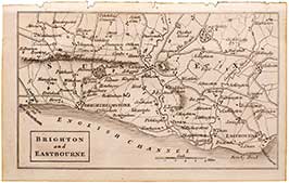
Brighton & Eastbourne Miniature Map
A very nice original, miniature, copper engraved map; showing the towns of Brighton and Eastbourne in East Sussex. Printed for Richard Phillips, London, and published....
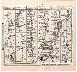
Bowle's Strip Map: Arundel To Chichester & London To Aylesbury
An original antique Strip Map showing Plate 8, The Road from London to Aylesbury (right), including Edgeware, Watford and Tring along the way. On the....
"Roads To..." London To Bognor (Including Eastbourne, Brighton Etc.) (1)
This antique copper engraving is Plate 2 from the first edition of "Laurie and Whittle's New Traveller's Companion", published 12th February, 1806. This artwork's full....
Midhurst Map From The Ordnance Survey (1)
An original antique lithographic map of Midhurst and environs, from the Ordnance Survey, by Lt. R. K. Dawson. This map dates from around 1832; it....
Switzerland Map
An original steel engraved map of Switzerland, drawn and engraved by J. Rapkin in 1851. This is a particularly fine and detailed map; decorated with....
Christchurch Map From The Ordnance Survey (1)
An original antique lithographic map of Christchurch and its environs, from the Ordnance Survey, by Lt. R. K. Dawson with lithography by J. Netherclift. This....
Thomas Moule's 1830 Map Of Hampshire (1)
A modern offset lithography print of Thomas Moule's original plates published over 180 years ago. Moule's plates were originally published in "The County Maps of....
Dugdale's Map Of Sussex
An attractive and detailed map of Sussex, drawn and engraved by J. Archer, Pentonville, London. This is an early steel engraving which dates from around....
"Roads To..." London To Bognor (Including Eastbourne, Brighton Etc.) (2)
This antique copper engraving is Plate 2 from a later edition of "Laurie and Whittle's New Traveller's Companion", published in 1818.
Its full title is....
Sussex Divisions Map
An original antique steel engraved map showing the Eastern and Western Divisions in Sussex. This map was engraved by J. & C. Walker after plans....
Sussex: Midhurst & Horsham Town Plans (1)
An original antique steel engraved map showing the towns of "Midhurst" (top) and "Horsham" (bottom) in Sussex. This map was engraved by J. & C.....
A Plan Of The Harbour Of Brest / A Plan Of The Bay & Roads Of Cadiz
An original antique copper engraved map, drawn and engraved by John Cary, this artwork is around 235 years old. The top map is entitled "A....
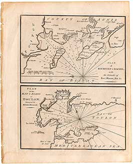
Plan Of Rochfort & Rochel / Plan Of The Bay & Roads Of Toulon
An original antique copper engraved map, drawn and engraved by John Cary. The top map is entitled "Plan of Rochefort & Rochel, with the Islands....
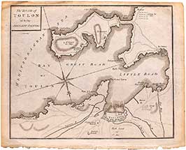
The Road Of Toulon With The Adjacent Country
An original antique copper engraved map, drawn and engraved by John Cary around 235 years ago. Entitled "The Road of Toulon with the Adjacent Country".....
Midhurst Map From The Ordnance Survey (3)
An original, antique, lithograph map of Midhurst and environs, from the Ordnance Survey, by Lt. R. K. Dawson. This map dates from around 1832, making....
Map Of Sussex
An original 'vintage' lithograph print showing a detailed map of Sussex. Printed in around 1923 by Geographica Ltd, 55 Fleet Street, London EC4. As this....
Contact us About this Artwork
I have an enquiry about:
This artwork is for Collection Only from The Midhurst Gallery either by you or by someone whom you authorise. Please refer to Para 7.12 of our T&Cs for details about Collections.
This Collection item requires to be in its own basket. If you have other items in your basket you will find them in your 'Saved for Later'.